
Hike The Mountains Of Aguadulce
Aguadulce's Mountains
27-01-2023 © Doris Leone
Online Hike Guide
The south of Spain is known for its rough mountains. After a wonderful and relaxing day at the beach, my boyfriend and I were in to do something adventurous. What could be better than having an amazing view of Aguadulce and, in the distance, Roquetas de Mar. From Aguagulce you can make a fairly easy climb to the antennas, but for the true adventurer among us, you can also go a step further and look for the hidden totem. Hike the mountains of Aguadulce!

Where to start and around what time?
If, like us, you want to watch the sunset from the antennas, keep in mind that from the starting point below to the antennas, you will spend about 30 to 40 minutes. Of course, this also depends on your physical condition and how fast you climb. Whether you are only going to visit the antennas or also the totem, check what time the sun sets and make sure you are at the antennas at least half an hour before sunset.
If you also want to go to the totem, keep in mind that it will take you at least 1.5 hours to get to the totem and back, this is not from the starting point, but from the junction, after the first climb up the mountain, from about 20 to 30 minutes.

All information about the route
Hike the mountains of Aguadulce, as the route starts just near the cemetery of Aguadulce, climb a bit until you reach a tunnel that goes under the highway, cross this tunnel to get to the other side. From here it is quite a bit of climbing, on a dirt road. It is not very tough, but the strength of the sun can make it a little tougher.
We made this climb in October, when the sun sets around 7:30 p.m., so we started our climb at 5:30 p.m. to be able to see the totem as well. Once at the top after half an hour, you will arrive at a junction, here you will come across the totem sign, follow the arrow and begin a beautiful hike.

Route to the Totem
The route is nicely balanced, there are some climbs and descents in it, but that keeps it active. The first bit is not too steep and at one point we arrived at a pile of stones built like a pyramid shape. Whether those will still be there when you make this climb, I dare not say, but for a moment it gave a perfect picture with the mountains in the background!
Because we left around 5:30 p.m., the temperature along with a breeze became more and more pleasant. After 15 minutes of walking, you continue climbing and descending, and at one point you walk on a nice and straight stretch. Look with astonishment around and enjoy the wonderful nature you are walking through.
At some point you will arrive at a blue pole with a skull on it, from there it will take you about 15 minutes to get to the totem. Note the last bit is a bit steeper downhill.


Route from the junction to the antennas
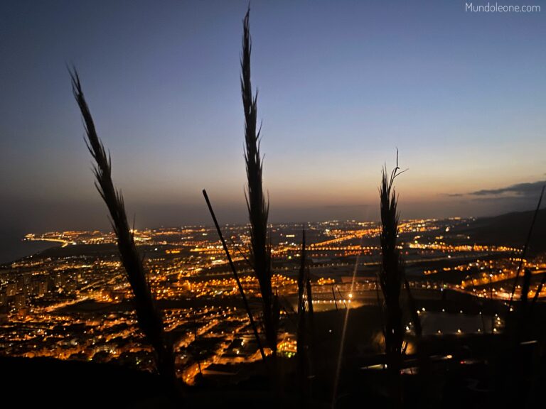
Once you get back down to the junction, it is about a 10-minute walk to the antennas. The views from the antennas are magnificent, you can see the sun setting in the mountains, which gives a magical image. Find a nice spot and relax with a nice drink you brought.
If you walk back, you may be able to see the moon rise over Almería, what cool views you have here!


Are there other routes?
Yes there are! Should you prefer a different route, you can choose to start from the port of Aguadulce. You then walk along the sea towards Playa del Palmer, from there you climb up a road and there you go under the highway again. This is also called the ‘Old Roman Path’. It will take you about half a day to get to the antennas, but one thing saves, the last part is not that long.

Prefer not to hike the mountains of Aguadulce?
You can also drive up by car if you have a 4×4, just keep in mind that the path is not paved and there may be a lot of loose large rocks on the path. If you have not done this before, I would advise against doing it. You can only do the route to the antennas by car.
Are you a real fanatic on a mountain bike? Then you can bike up and even visit the totem, although I would do the last 40 meters on foot. We came across such a fanatic on mountain bike!


What to bring?
- Enough water, ± 1.5 litres p.p.
- Torch or headlamp (can be very handy when going down the mountain at night)
- Daypack with a first aid kit
- DEET (for the mosquitoes in the evening)
- Sunscreen
- Have a full phone and use Google Maps (generally the route is clearly marked)


